Trail On foot Sant Feliu de Pallerols - Sant Feliu de Pallerols-Sant Pere Sacosta-La Salut - Photo

Sant Feliu de Pallerols-Sant Pere Sacosta-La Salut

Tous les sentiers balisés d’Europe PRO

© OpenStreetMap contributors
Length
Length
11.8 km
Max alt
Max alt
1125 m
Uphill gradient
Uphill gradient
681 m
Km-Effort
Km-Effort  
21 km
Min alt
Min alt
475 m
Downhill gradient
Downhill gradient
682 m
Boucle
Boucle
Yes
Signpost
Signpost
Creation date :
2022-02-14 15:45:37.303
Updated on :
2022-02-14 15:45:37.303

(0 Reviews)

On foot
On foot
4h45
Difficulty : Medium

Scan this QR Code to open this trail in the SityTrail application

FREE GPS app for hiking

Logo SityTrail SityTrail

IGN / Geographical institutes

Download SityTrail from the App Store Download SityTrail from Google Play

Logo SityTrail SityTrail World

The world is yours!

Download SityTrail from the App Store Download SityTrail from Google Play Download SityTrail on Huawei AppGallery

About

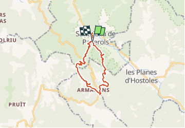
Trail On foot of 11.8 km to be discovered at Catalonia, Girona, Sant Feliu de Pallerols. This trail is proposed by SityTrail - itinéraires balisés pédestres.

Description

Breu introducció. Ruta circular per Sant Feliu de Pallerols( La Garrotxa), que passa pel volcà de Sant Marc, les restes de l´ermita de Sant Pere Sacosta, la fageda i el paratge de Roques Encantades, i el santuari de La Salut. Vistes panoràmiques en alguns llocs que valen la pena l´esforç. Dades tècniques: Durada de la…

Website: https://senderismegirona.org/2019/02/12/ruta-69-sant-feliu-de-pallerols-a-st-pere-sacosta-roques-encantades-i-la-salut/

Photos

Positioning

Country:
Spain
Region :
Catalonia
Department/Province :
Girona
Municipality :
Sant Feliu de Pallerols
Location:
Unknown
Start:(UTM)
459118 ; 4658074 (31T) N.

Trails nearby

Trail On foot la Vall d'en Bas - L'altiplà de Collsacabra - Photo
On foot
PRO

On foot

Easy
la Vall d'en Bas, Catalonia, Girona, Spain
10.9 km | 17.9 km-effort
4h 3min
No


Close
My subscriptions